Executive Summary
Machhava is a small village in the Kheralu taluka of Mehsana district, Gujarat. The village has a population of 1,529 people, with a slightly higher number of males (781) than females (748). With 311 households, the village maintains a rural character. The literacy rate is a respectable 79.4%, indicating a good level of education among the residents.
The village's economy is primarily driven by agriculture. A significant 82.0% of the workforce is involved in agricultural activities. Machhava's access to basic infrastructure such as schools, health sub-centers, and bus services makes it a potentially attractive location for strategic investment, despite its rural setting.
Land investors should carefully examine land records and local regulations before making any decisions. Future development might be impacted by the forthcoming Mehsana Development Plan 2045. It is essential to check the TownPlanMap website for updates.
Location and Geography of Machhava
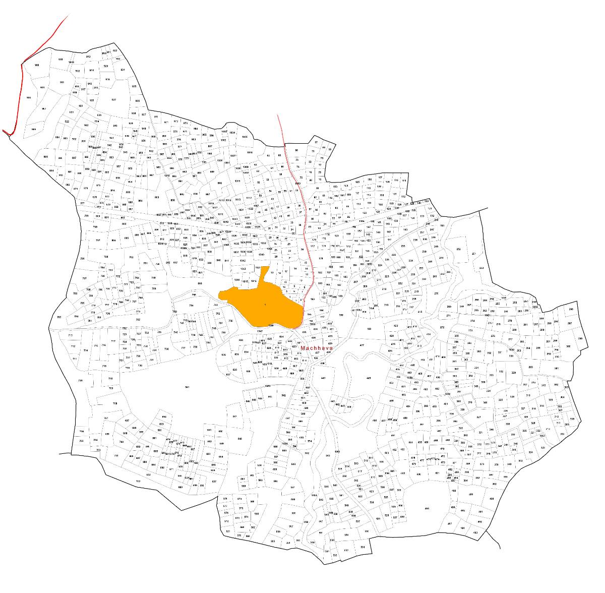
Machhava is situated in the Kheralu taluka of the Mehsana district in Gujarat. Kheralu, the nearest town and sub-district headquarters, is located approximately 10 km from the village. The district headquarters, Mahesana, is about 42 km away. The village is accessible by road, which connects it to nearby towns and cities.
The total geographical area of Machhava is 775.8 hectares. This provides ample space for agricultural activities and potential development. The population density is low, with only 2.0 persons per hectare. This indicates a relatively spacious living environment.
The terrain around Machhava is typical of the North Gujarat region. It is generally flat, making it suitable for agriculture. Common soil types found in this region include alluvial and sandy loam soils. These soils are conducive to growing crops like cotton, millet, and pulses.
Water resources in Machhava are critical for agriculture and daily life. The primary sources of water include groundwater and rainfall. Farmers often rely on wells and borewells for irrigation. The availability of water resources greatly influences the agricultural productivity of the region. Investors should assess water availability before committing to any projects. The PM Krishi Sinchayee Yojana is also relevant. It aims to improve water use efficiency in agriculture. (https://pmksy.gov.in/)
The climate of Machhava is semi-arid, with hot summers and mild winters. The monsoon season, which lasts from June to September, brings essential rainfall. Understanding the local climate and water availability significantly affects sustainable agricultural practices. It is also important for planning any future developments in the village.
Socio-Demographic Profile
Machhava village has a population of 1,529 people according to the Census of India 2011. Among these, 781 are males and 748 are females. This gives the village a sex ratio of 958 females per 1,000 males. This ratio is relatively healthy compared to some other regions in India.
The village comprises 311 households. This indicates a small, close-knit community. The literacy rate in Machhava is 79.4%. This is a positive sign, suggesting that a significant portion of the population is educated. Education can contribute to better economic opportunities and overall development.
The Scheduled Castes population in Machhava is 117. This data is important for understanding the social composition of the village. It also helps in implementing targeted development programs for marginalized communities.
The worker participation rate in Machhava is 30.1%. This figure represents the proportion of the population that is engaged in some form of economic activity. A deeper look into this reveals that a large percentage of the workforce is dependent on agriculture.
Specifically, 82.0% of the workforce is engaged in agriculture. This emphasizes the agrarian nature of the village economy. Further breakdown reveals that there are 460 total workers in the village. Out of these, 285 are main cultivators and 92 are agricultural laborers. These numbers highlight the dominance of agriculture as a source of livelihood.
Understanding the socio-demographic profile matters for investors. It provides insights into the local population, their educational levels, and their economic activities. This information helps in making informed decisions about potential investments and development projects. The data directly impacts workforce availability and the feasibility of different business ventures.
Planning and Government Regulations
Understanding the planning and government regulations is important for any property buyer or land investor in Machhava. This includes knowledge of FSI/FAR rules, land use zoning, NA conversion processes, and alignment with the Mehsana Development Plan. However, specific FSI/FAR (Floor Space Index/Floor Area Ratio) rules for Machhava were not available in the provided census data. These regulations dictate the maximum permissible construction area on a given plot of land. Investors need to consult the local municipal authorities or the Kheralu Taluka office to obtain accurate FSI/FAR values.
Land use zoning regulations define how land can be used within the village. These zones typically include residential, commercial, agricultural, and industrial areas. Specific zoning regulations for Machhava would be outlined in the Mehsana Development Plan. Investors must ensure that their intended land use complies with the designated zone.
The NA (Non-Agricultural) conversion process is essential if agricultural land is to be used for non-agricultural purposes, such as residential or commercial development. In Gujarat, this process involves applying to the relevant authorities. This is usually the Mamlatdar or the Collector's office. The application requires detailed land documents, project plans, and payment of conversion fees. The process ensures that the land is suitable for the intended non agricultural use.
The Mehsana Development Plan is a comprehensive document that outlines the planned development of the entire Mehsana district, including villages like Machhava. This plan is created by the local town planning authorities and is updated periodically. The Mehsana Development Plan 2045 is anticipated soon. Keep checking the TownPlanMap website for its release. It will be essential for investors to align their projects with the objectives and guidelines outlined in this plan.
The Digital India Land Records Modernization Programme (DILRMP) aims to modernize land records and make them accessible online. (https://dolr.gov.in/) This initiative improves transparency and reduces land related disputes. Investors should leverage this resource to verify land ownership and land use details.
Investors should also be aware of the regulations pertaining to environmental clearances. Depending on the scale and nature of the project, environmental impact assessments (EIAs) may be required. These assessments evaluate the potential environmental impact of the proposed development. Compliance with environmental regulations is mandatory for sustainable development. NITI Aayog's sustainable development goals (SDGs) are also applicable.
Physical Infrastructure
Road connectivity is a vital aspect of Machhava's infrastructure. The census data indicates the availability of bus service in the village. This suggests that Machhava is connected to nearby towns and cities by road. However, specific details about the types of roads (e.g., paved, unpaved) and their condition are not available. Good road connectivity supports transporting agricultural produce, accessing markets, and facilitating the movement of people.
Power supply is another crucial infrastructure component. While the census data confirms mobile coverage, it does not explicitly mention the availability of electricity. However, it is highly probable that Machhava has access to electricity, given the widespread electrification efforts in Gujarat. Reliable power supply is important for agricultural activities, household needs, and supporting local businesses.
Information on water supply infrastructure is not explicitly provided in the census data. Typically, rural areas in Gujarat rely on a combination of sources for water. These can include groundwater, wells, and piped water supply schemes. The Jal Jeevan Mission, a government initiative, aims to provide piped water supply to all rural households by 2024. (https://jaljeevanmission.gov.in/) Investors should investigate the current water supply infrastructure and potential for improvement.
The availability of telecom coverage, specifically mobile coverage, is confirmed in the census data. This indicates that residents of Machhava have access to mobile phone services. This is important for communication, accessing information, and conducting business. Improved internet connectivity can further enhance opportunities in the village.
Physical infrastructure is central to the development of any region. Investors should carefully assess the available infrastructure. Also consider potential improvements before making investment decisions. The PM Gati Shakti National Master Plan aims to improve infrastructure connectivity across India. (https://pmgatishakti.gov.in/)
Social Infrastructure
Machhava village has basic social infrastructure to cater to the needs of its residents. According to the Census 2011 data, there is 1 school in the village. This school is a primary school. This means that children have access to elementary education within the village. For higher education, students would likely need to travel to nearby towns like Kheralu or Mahesana.
In terms of health facilities, Machhava has 1 sub centre. A sub centre is a basic healthcare unit. It provides essential medical services to the local population. For more specialized medical treatment, residents would need to visit hospitals or clinics in Kheralu or Mahesana.
The availability of local institutions in Machhava is not detailed in the provided census data. However, it is common for villages in Gujarat to have community centers, self help groups, and other local organizations. These institutions play a crucial role in promoting social interaction, economic development, and community welfare.
The Anganwadi centers are also important. Although not specifically listed in the census data, these provide early childhood care and education. They also provide nutrition to pregnant women and lactating mothers. These services are crucial for improving health outcomes.
The presence of social infrastructure contributes to the overall quality of life in the village. It is an important factor to consider for potential residents and investors. Access to education and healthcare facilities is needed for the well being of the community. Improved infrastructure can lead to better social and economic outcomes.
Land Records Verification
Verifying land records is a critical step for any property buyer or investor. This process helps to ensure clear ownership, identify any encumbrances, and prevent fraudulent transactions. In Gujarat, the process involves accessing online portals and visiting the local land revenue offices.
The primary online portal for accessing land records in Gujarat is the e-Dhara portal. This portal provides access to various land records documents, including:
7/12 extract (Satbara Utara): This document provides details of land ownership, survey number, area, and cultivation details.
Village Form 6 (Hak Patrak): This register records changes in land ownership due to sale, inheritance, or other transactions.
Index II: This document contains registered sale deeds and other transfer documents.
To access these records online, you will need the survey number, village name, and other relevant details. The e-Dhara portal allows you to view and download these documents for a nominal fee.
Checking for mutations is also essential. Mutation refers to the transfer of title when a property is sold or inherited. It is important to verify that the mutation has been duly recorded in the land records. You can check the mutation status by visiting the Mamlatdar office or through the e-Dhara portal.
Verifying the title chain involves tracing the history of ownership of the land. This can be done by examining the registered sale deeds and other transfer documents for the past several years. This helps to ensure that the current owner has a clear and marketable title to the property. You can obtain copies of these documents from the sub registrar's office.
It is advisable to engage a lawyer specializing in property law to assist in the land records verification process. A lawyer can conduct a thorough title search, identify any potential issues, and provide legal advice.
In addition to online portals, it is also important to visit the local land revenue offices. These include the Talati office and the Mamlatdar office. These offices maintain physical copies of land records and can provide additional information.
The Digital India Land Records Modernization Programme (DILRMP) aims to streamline and digitize land records. (https://dolr.gov.in/) Take advantage of the available resources to ensure a safe and secure land transaction.
Economic Engine of Machhava
The economy of Machhava village is predominantly agrarian. According to the Census 2011 data, 82.0% of the workforce is engaged in agriculture. This clearly indicates that agriculture is the primary source of livelihood for the majority of the population.
Out of the 460 total workers in the village, 285 are main cultivators. This means that they are directly involved in cultivating their own land. Additionally, there are 92 agricultural laborers. These laborers work on the fields of other farmers. This data highlights the significance of agriculture in the village's economy.
The main crops cultivated in Machhava likely include crops typical of the Mehsana district, such as cotton, millet, pulses, and oilseeds. The productivity of these crops depends on factors such as rainfall, irrigation facilities, and soil quality.
The proximity of Machhava to Kheralu (10 km) and Mahesana (42 km) influences the economic opportunities available to the residents. These towns serve as markets for agricultural produce and provide access to other goods and services. Commuting patterns likely involve residents traveling to these towns for work, trade, and accessing facilities not available in the village.
While agriculture is dominant, there may be some non agricultural activities in the village. These could include small businesses, shops, and cottage industries. However, the scale of these activities is likely limited.
The lack of specific data on nearby industries makes it difficult to assess the extent of industrial influence on Machhava's economy. However, the presence of industrial areas in Mehsana district could indirectly create employment opportunities for some residents.
To diversify the economy and improve the living standards of the residents, efforts could be directed towards promoting non agricultural activities, skill development, and improving market access for agricultural produce. The Ministry of Housing and Urban Affairs promotes livelihood opportunities. (https://mohua.gov.in/)
Investment Potential and ROI
Investing in land in Machhava, Mehsana, Gujarat, presents both opportunities and risks. Land prices in the region depend on factors like location, land use zoning, accessibility, and potential for development. Gathering data on recent land transactions in Machhava and nearby areas is essential to understand current market rates.
Given that Machhava is primarily an agricultural village, the investment potential is closely tied to the agricultural sector. Improvements in irrigation facilities, adoption of modern farming techniques, and access to markets can enhance the value of agricultural land. Government schemes and subsidies aimed at promoting agriculture can also positively impact land values.
The proximity of Machhava to Kheralu and Mahesana offers potential for residential and commercial development. As these towns grow, there could be demand for land in Machhava for housing, businesses, and other amenities. The upcoming Mehsana Development Plan 2045 will be a key factor influencing future land use and development possibilities.
However, investors must be aware of the risks associated with land investments in rural areas. These include:
Fluctuations in agricultural commodity prices: This can impact the profitability of agricultural land.
Dependence on monsoon rains: Erratic rainfall can affect crop yields and land values.
Land ownership disputes: Clear land titles are crucial for secure investments.
Regulatory hurdles: Obtaining necessary approvals for land use conversion and development can be time consuming and complex.
A balanced assessment of the investment potential should consider both the opportunities and the risks. Investors should conduct thorough due diligence, consult with local experts, and develop a realistic investment strategy. Diversifying investments and considering a long term investment horizon can help mitigate risks. The NITI Aayog promotes strategic investments. (https://niti.gov.in/)
Disclaimer: This analysis is based on the available census data and general information. It does not constitute financial or investment advice. Investors should conduct their own independent research and seek professional advice before making any investment decisions. Land investments are subject to market risks and regulatory changes.
Strategic Analysis: Growth, Strengths, Weaknesses, SWOT
Machhava, like many villages in India, possesses both strengths and weaknesses that shape its growth outlook. A SWOT analysis helps to understand these factors and devise strategies for sustainable development.
Strengths:
Relatively high literacy rate: The literacy rate of 79.4% indicates a good foundation for education and skill development.
Adequate sex ratio: The sex ratio of 958 females per 1,000 males is relatively balanced.
Basic infrastructure: The presence of a primary school, sub centre, and bus service provides essential amenities.
Proximity to towns: The village's location near Kheralu (10 km) and Mahesana (42 km) provides access to markets and services.
Weaknesses:
High dependence on agriculture: The fact that 82.0% of the workforce is engaged in agriculture makes the economy vulnerable to fluctuations in agricultural output.
Low worker participation rate: The worker participation rate of 30.1% suggests a need to create more employment opportunities.
Limited social infrastructure: The presence of only a primary school and a sub centre indicates a need for improved education and healthcare facilities.
Lack of specific data: Absence of specific data on water supply, sanitation, and other amenities limits the ability to assess the overall quality of life.
Opportunities:
Diversification of economy: Promoting non agricultural activities, such as small businesses, cottage industries, and tourism, can create more employment opportunities.
Skill development: Providing vocational training and skill development programs can enhance the employability of the youth.
Infrastructure development: Improving road connectivity, water supply, and sanitation can enhance the quality of life and attract investment.
Leveraging government schemes: Utilizing government schemes aimed at rural development, agriculture, and infrastructure can accelerate growth.
Threats:
Climate change: Erratic rainfall, droughts, and floods can negatively impact agricultural productivity.
Land degradation: Soil erosion and loss of fertility can reduce agricultural yields.
Migration: Out migration of youth in search of better opportunities can lead to a decline in the village's population and workforce.
Competition: Competition from other regions and global markets can impact the competitiveness of local industries.
Based on this analysis, Machhava can focus on diversifying its economy, improving infrastructure, and leveraging government schemes to achieve sustainable growth. Addressing the threats posed by climate change and land degradation is also crucial for ensuring long term prosperity.
Frequently Asked Questions
- What are the current land prices in Machhava?
- Land prices vary based on location, zoning, and accessibility. Check recent sales data at the sub registrar's office and consult with local property brokers for current rates.
- How can I verify land ownership in Machhava?
- Use the e-Dhara portal to view 7/12 extracts and other land records. Also, visit the Mamlatdar office for physical verification.
- What is the process for converting agricultural land to non agricultural use?
- Apply to the Mamlatdar office with land documents and project plans. Pay the required conversion fees. Ensure compliance with zoning regulations.
- What are the future development plans for Machhava?
- Refer to the Mehsana Development Plan 2045, available on TownPlanMap, for land use zoning and planned infrastructure projects.
- What are the main sources of water in Machhava?
- The main sources of water are groundwater and rainfall. Check the availability of piped water supply schemes and irrigation facilities with the local authorities.
Conclusion
Machhava, with its population of 1,529 and literacy rate of 79.4%, represents a typical Indian village with its own set of opportunities and challenges. Its strong agricultural base, with 82.0% of the workforce engaged in agriculture, provides a foundation for economic activity. The village benefits from basic infrastructure. This includes a primary school, a sub center, and bus service. These connect it to nearby towns.
However, the village also faces challenges. The economy needs diversification, worker participation requires improvement, and infrastructure needs enhancement. Potential investors and residents should carefully assess these factors and conduct thorough due diligence before making any decisions.
The upcoming Mehsana Development Plan 2045 will play a crucial role in shaping the future of Machhava. This will impact land use, development possibilities, and overall growth. By leveraging its strengths, addressing its weaknesses, and capitalizing on opportunities, Machhava can strive for sustainable development.